The transition of deep south climate to one a bit cooler had already taken place in Northern Georgia, but I was still getting used to it. The lack of moss draping from the trees was still something new to me, but every region has a beauty to it. I prefer to stay at state and national parks because they usually have a nucleus of some sort of natural or historic wonder. Last night I had stayed at Watson Mill, which was based on the beautiful covered bridge build in 1885, and tonight I was headed for Devil’s Fork S.P. in South Carolina, near the city of Salem. I had read a few reviews saying that it was a nice place to camp, and so I expected something at least decent. I kept thinking that eventually I’ll find a bad egg, but yet again I was surprised by a beautiful camp ground that sits in the woods along the coast of Lake Jocassee. I could see the water from my campsite so I set up my tent in a hurry to walk down to the water.
Lake Jocassee as seen from the Devil’s Fork State Park campground. May 18, 2011
The water was beautiful, I didn’t know that such a blue color existed in waters beyond the Bahamas. Lake Jocassee is aa man-made lake created in 1973 for both recreation and hydroelectricity production (at the 385’ tall dam). The shore of the lake that sits against the campground consists mostly of exposed metamorphic rock outcrops that have been highly weathered. The ones that stick out of the water literally crumble with your hand. I tried to find more detailed information about the geology of the area prior to the damming of the lake but I have had no luck. Feel free to comment, or send an e-mail to geojeep.com@gmail.com if you have more information. I would love to know, and love to share it with my readers.
Metamorphic rocks outcropping in Lake Jocassee, South Carolina. May 18, 2011Metamorphic Rock outcrop on Lake Jocassee, lens cap for scale. May 18, 2011Close up showing how it crumbles easily into sand. Metamorphic Rock outcrop on Lake Jocassee, South Carolina, May 18 2011
I had planned this day to be a relaxing day, so I spent most of it at camp resting on the shoreline. I cooked my sausage over the campfire, and spent the evening in my chair reading Simon Winchester’s novel “A Crack in the Edge of the World: America and the Great California Earthquake of 1906”. It was a much needed relaxing evening, in the beautiful surroundings of Devil’s Fork.
Lake Jocassee at Devil’s Fork State Park South Carolina. May 18, 2011Lake Jocassee at Devil’s Fork State Park, South Carolina. May 18, 2011
Nothing worthwhile is achieved without great effort. How you can determine how truly dedicated you are to a cause is by evaluating how long you are willing to try before giving up. Working hard really does pay off, whether it be the intended result or not. Sometimes the result is even better.
The Geology Dept. Banner at the University of Georgia. May 17 2011
Today I slept in a little, with a drive of only 4 hours planned for the day. I was going to head from Savannah Georgia to Athens, Georgia, the hometown of one of my graduate school hopefuls. I had been emailing one of the higher up faculty there in hopes of meeting them while I was here, but unfortunately both of the gentlemen I had been talking to were going to be gone during this part of the summer. Since I had still planned on being in the area I figured it would still be worth a campus visit so I could at least see the campus, the geology building, and the town of Athens and get a feel for the area.
The Hydrangea at the University of Georgia. May 17, 2011
I arrived in Athens about 3pm, and after finding a visitor parking area, I wandered around the campus (with guidance from the campus map board that was stationed near my parking garage). The University of Georgia is quite larger than what I am used to navigating. I don’t know how big Athens really is, but I’m pretty sure that the U of G consumes almost all of it. The campus is really pretty, well landscaped with local plants like blue hydrangea, lilies, and various trees. Every nook and cranny between buildings is well landscaped to include benches and gathering places. It seems no matter where you go you would feel like you have found your own personal oasis. Perhaps this is because it is summer and most of the students and faculty are absent, but I’d like to pretend it is like this all year around.
I dont know why I take a picture of the university stadiums, I don't really follow college sports. None-the-less, here is the University of Georgia's stadium. May 17, 2011
I found the shared Geology/Geography building with little difficulty. The building was open so I went in and wandered. As with all schools, everything was clearly labeled, and those that weren’t were easy to distinguish. The floor with the rocks was the geology floor. The floor with the giant globe would be the geography floor….in general. I was reading the directory and then looking at some pictures when I noticed a familiar name on one of them. It was the very man who was coauthor of the research the man I had been communicating with published. Not even two minutes later I see a walking image of the picture I had just been examining, so I stop and ask if it was indeed him.
The Geography/Geology building at the University of Georgia. May 17, 2011
I had caught him at a perfect time, he says. He was just wandering the building, bored, and considering visiting the library to do some mindless reading. He would be more than happy to show me around and talk to me about what the University of Georgia has to offer. We sat and talked about speleothems from different parts of the world for a time, and then he showed me some of the research they were doing now, opening up the labs and showing me specimens. He told me what type of TA and RA offers they typically make- most of the information I need to know to make a solid decision. I was incredibly lucky to have met him, as he is well known in the field. I had considered for a short moment not visiting the campus since the two men I had been communicating with weren’t going to be there, but I was still determined to get as much information as I can. It turns out the determination paid off, well. That makes 2 grad school potentials down, only 3 more to visit to get a good idea of who offers what.
Some of the local produce I picked up at a roadside fruit stand in Georgia. May 17, 2011The white peaches I got, first of the season, from a local produce stand in Georgia. May 17, 2011
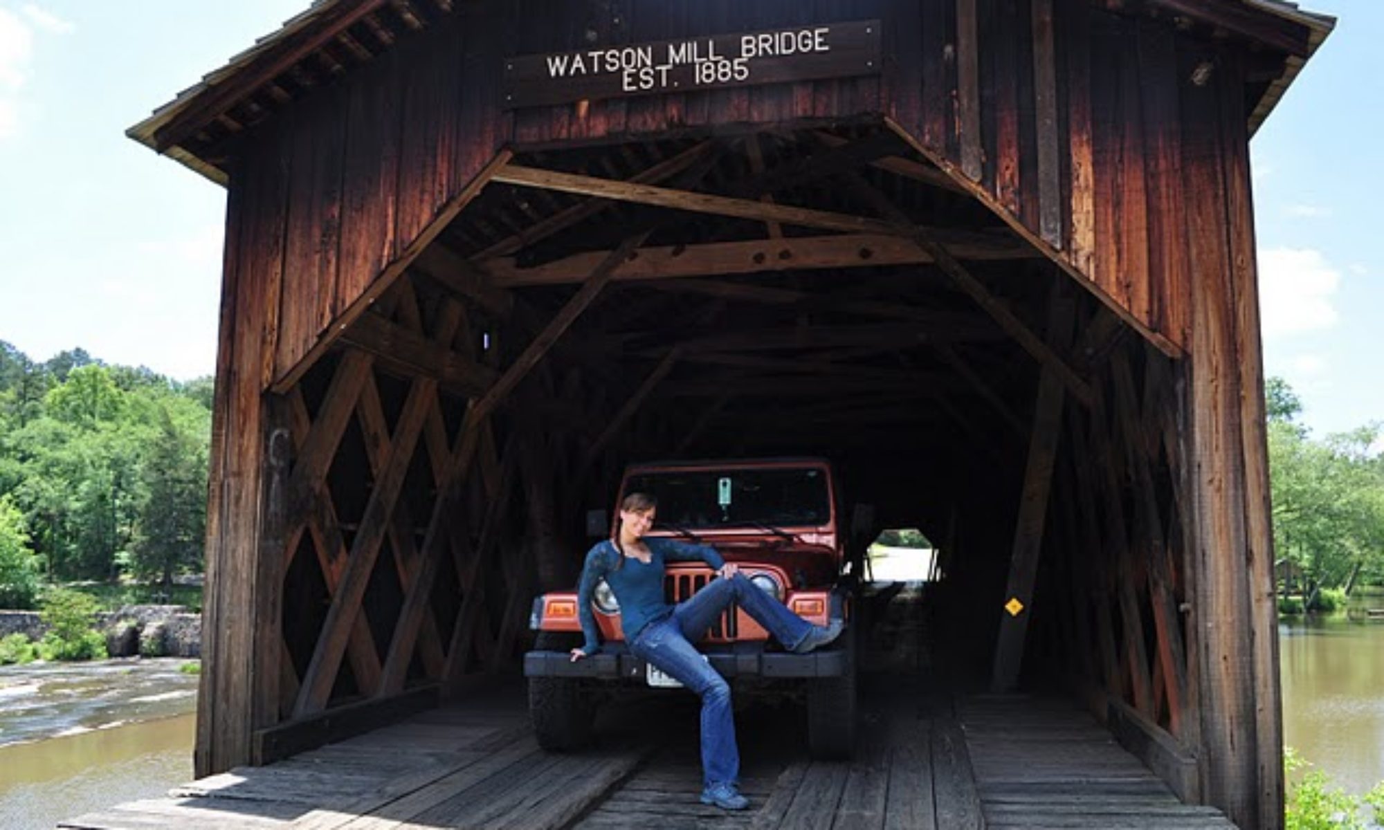
After my visit with the University of Georgia I headed off to my next campsite: Watson Mill Bridge State Park. On the way to Athens to visit the University of Georgia I had stopped by a local fruit stand and picked up some local produce. I purchased 4 1st-of-the-season white peaches (grown from the standowners orchards), 1 ripe tomato, 1 vidalia onion (from Vidalia, GA, so the real deal), and a few potatoes- all for about $3. You can’t beat that. After stopping by a grocery store to pick up some sausage to slice up, and the leftover jalepeno from my cajun hobo dinner I cooked in Gulf State Park on Day 5, I had a really good dinner in the making.
My tasty dinner made of local produce (and a jalepeno and sausage). May 17, 2011 Watson Mill Bridge State Park Georgia
It turns out the park was absolutely gorgeous. I yet again had chosen the best park I could have in the area. The campsites were large, and the entire area was less than half occupied, there was a quaint wooden covered bridge, the nucleus of the park itself, and trails, waterfalls and more. I had to cook dinner and then eat it while walking on the trails I was so excited to experience them before dark.
My campsite at Watson Mill Bridge State Park in Georgia. May 17, 2011
The place stimulates each of the five senses: The smell of warm cedar. The sound of falling water. The sight of stone mill ruins and a covered bridge. The taste of camp cooked food. And the feel of a cooler, forested climate. It all added up to the fact that I had made the transition from the humid, warm south (which I did love) to the beginnings of the Appalachian Mountains. I was still in the state of Georgia, but something had clearly changed.
The old Mill Ruins you can find if you walk along the trails at Watson Mill State Park in Georgia. May 17, 2011
I couldn’t get enough of the park. I had planned the next day to be leisurely so I stayed there until almost check out time, taking pictures and relaxing in the canopy of the cedars and other trees. I was tempted to stay there another night, but I had already planned to visit another well-acclaimed state park up in South Carolina: Devil’s Fork State Park. I am determined to experience as much of America as I can on this trip, and my dedication had paid off today- It will certainly pay off tomorrow. I’ll see you there-
Nicole
The covered bridge that crosses the river that runs over a lot of granitic rocks. May 17, 2011 at Watson Mill Bridge State ParkTaking pictures of Watson Mill Bridge in Northern Georgia. May 17, 2011
Luck. It’s one of those whimsical ideas that is often tied to symbolic findings like a four-leaf clover and a bird that drops a little present on your head in flight. Something many don’t truly believe in, yet so many people seem to have it. The Spanish appear to have had luck when they stumbled upon St. Augustine, the lighthouse of the same settlement seems to have had tremendous luck, and even I have had many good hands dealt my way. Luck- Could it be real?
I got up early this morning, a busy day of sightseeing on the books, and headed to the only WiFi access point in Anastasia State Park, located at the beach shop. I settled down in the rising sun with my laptop, uploading pictures of the previous day for all of you to enjoy, when I noticed a few people collecting at the beach. One man was sitting up at the beach overlook deck with a camera on a tripod, and a few people were trickling their ways onto the beach. They weren’t wearing beach attire, nor was it warm enough to swim if they had been. I dismissed it as a group family photo in the making and went about my business. Soon more people began to show up, all toting their DSLR cameras and chatting a little too lively for such an early hour on the east coast. Then someone approached me: “Are you going to watch the shuttle launch?”.
The launch of Shuttle Endeavour as viewed from Anastasia State Park Beach. May 16, 2011.
I almost leapt out of my seat- could it really be that today was the day that they launched the space shuttle Endeavour? It turns out it certainly was- and I was close enough to Cape Canaveral to see if from my vantage on the beach. I was totally unprepared to take such a photograph, so the few that I did get aren’t all that great- but I did get them, and I did get to see it launch. Many thought this was the last launch of the shuttle Endeavour, but according to news articles this was the next-to-last.
If you guys are really hard core about seeing the shuttle launch keep updated on the real “last launch”. Maybe you can find a way to venture out there? Even if you can’t get down to Cape Canaveral, you now know of a great place to camp out and view it from: Anastasia State Park. According to the volunteer who stands atop St. Augustine Lighthouse once a week, this launch view wasn’t as good as it usually is due to some haze. He has been living in St. Augustine since the 1980s, and hasn’t missed a launch since. He even got to work early so he could view the launch from atop the lighthouse. If you are lucky enough, perhaps you can watch the last ever launch of Endeavour from atop the lighthouse.
The St. Augustine Lighthouse. May 16, 2011. Every lighthouse has it's own distinct scheme so that ships can recognize where they are. Climbing up isn't bad, it's climbing down that makes me nervous everytime. St. Augustine Lighthouse.
The St. Augustine Lighthouse was my first planned trip of the day. I had already visited the lighthouse once, but it is something worth seeing again. The current lighthouse stands 165’ high and has been standing there since 1874. It is built of brick and steel, both crafted here in the U.S., and is the oldest standing brick structure of St. Augustine. When you visit you have to climb 219 stairs to reach the top (sound exhausting, it is!).
A small sample of the stairs of St Augustine Lighthouse. May 16, 2011The stairs are very pretty to look at. St. Augustine Lighthouse May 16, 2011
Many Florida lighthouses had a lot of trouble staying upright: the soft sands of the coast proved to be a less-than-stable base for the heavier lighthouses of the late 1800’s. St. Augustine has a sturdy layer of coquina for the lighthouse to sit atop, keeping it from the same fate of many other lighthouses in the state. The lighthouse has had several close calls, such as Hurricane Dora and a few other hurricanes, and a couple earthquakes. Fortunately (and perhaps luckily?) the St. Augustine lighthouse has stood tall. (Visit their website at www.staugustinelighthouse.com)
This funny mirror was on the ground. It made for a neat vantage point for a picture. St. Augustine Lighthouse May 16, 2011The view of Castillo de Sand Marcos as you drive past. May 16, 2011. St. Augustine Florida
It was now time to see to the Castillo de San Marcos, the oldest masonry fort in the continental U.S. Built by the Spanish beginning in 1671, the fort was something to be feared by many enemies. In 1702 British naval & land forces attacked St. Augustine and a not-yet-completed Catillo de San Marcos. The British destroyed the city, but were unable to take on the fort and retreated. In 1728 British troops once again decided to march into St. Augustine, but saw the fort and promptly turned around and left. In 1740 the British governor of Georgia also attacked St. Augustine, but could not capture the fort.
The view of the entrance of Castillo de San Marco when standing atop the fort. May 16, 2011. St. Augustine, FL.
Why was the fort so impenetrable? Was it because of the architectural layout or the cannons? Probably this, and due to the building material provided to the Spanish from Anastasia island, the very rock that the St. Augustine lighthouse stood upon many years later: Coquina.
Close-up of a coquina block at the quarry. St. Augustine, FL Anastasia S.P. May 16, 2011
Geology time: So what is this coquina stuff, anyways? Literally “coquina” translates from Spanish to “tiny shellfish”. Aptly named, coquina is a type of limestone composed of shells, clay and sand that have been chemically bonded together. It may look brittle, but trust me when I say the stuff is tuff, I tested a block of it. So, where did it come from?
The coquina quarry (A historic site) in Anastasia S.P. St Augustine, FL May 16, 2011
Luckily my campsite hosts the spot where the Spanish started quarrying the coquina in 1671. I was able to visit it and learn a bit about the geology of the area. In the Pleistocene epoch there were a series of glaciation/melting patterns that allowed shells, clay and sand to accumulate during the high sea levels, and to cement together when it was exposed to rainwater during times of low sea levels. This developed the Anastasia formation, a formation that stretched from the Northern end of Anastasia Island all the way south to Palm Beach, FL (250 miles long) and is about 330 miles wide, most of it stretching into the Atlantic Ocean.
The wall built of shells. The coquina blocks of the Castillo de San Marco.
The coquina is a very strong rock when dry, so to cut it the Spanish settlers would cut the stone while it was wet, and then allow it to dry for up to a year before incorporating it into the Castillo. It was such a useful building product that one third of St. Augustine’s buildings were made of it by 1764. The Spanish were very (lucky, perhaps?) to have such a building material readily available.
It seems that in the case of my observation of shuttle Endeavour, the long-standing life of St. Augustine Lighthouse and the Spanish settler’s find of the coquina to build the Castillo all speak for the case of luck. It must be real, then…Luck has it. Right?
Let’s look back on the reality of the situation. St. Augustine Lighthouse was built in 1874 to replace a Spanish watchtower built in the late 1500’s. The old watch tower tumbled to the sea in a storm in 1880. It stood for 300 years, a span of time yet to be proven by the “New” St. Augustine Lighthouse. The Castillo de San Marcos was built beginning in the 1670s to replace the 9th (yes, you read right, NINTH!) fort since 1565. It seems that all of these events add up to being in the right place at the right time. It may seem like luck, but it is actually due to ingenuity and being able to see the bright side of things no matter what. The Spanish and other settlers of St. Augustine were smart enough to use what was available to them on their very own Anastasia island, buried beneath the sand dunes and soil (called hammocks). We all know I have had my fair share of mishaps- and the fact that I was able to see something as spectacular as the shuttle launch isn’t due to luck: It is due to my dedication to adventure and putting myself in places where things can, and will, happen.
If you are sitting around waiting for your luck to turn around you aren’t going to get much. Luck isn’t a rabbit’s foot on a keychain or eating black eyed peas on New Year’s Day. Luck is constructed out of your own determination and will. Created by you, for you, by continuing to push forward even after you fail again and again. Don’t let the first 9 fallen forts force you to give up. Look around you, use the tools you have been given, and manifest your own destiny.
Some colorful beetles (or something of the like) at the coquina quarry in Anastasia S.P. May 16, 2011Chocolates from Whetstone Chocolates of St. Augustine. I had a small snack from here- I was saving my calories (and my money) for a fabulous dinner in Savannah tonight. May 16, 2011Whetstone Chocolates of St. Augustine. Very good stuff. They even have chocolate dipped bananas, a personal fave.I'm standing in the watch tower of the Castillo de San Marco. May 16, 2011The view down a canon if you were getting ready to take down an enemy ship at the Castillo de San Marco in st. AugustineThe sanctuary at Castillo de San Marco, the font on the wall and the altar on the left side of the pic. May 16, 2011While I toured the Castillo de San Marco National Park officials took precautions to preserve artifacts by vacuumn air out of a case to reduce humidity. May 16, 2011Where the men would sleep at Castillo de San Marco while on duty (They didn't live at the fort)Some of the lighthouse prisms at St. Augustine Lighthouse (when you get to the top and are looking at the light, look up!)
I'm about to ascend all of those stairs- all 219 of them! May 16, 2011 St. Augustine Lighthouse
I climbed all the way to the top of St. Augustine Lighthouse…again! May 16, 2011
The roots of the sea oat plant can be 10 times the size of the plant above the sand. A grass like plant that whips around in the wind at the surface has deep ties into the sand it calls home. The roots are designed to allow the sea oat to survive on the sand dunes, where a large root surface area allows the scarce water to be found. The mosses that are so prevalent in the south, however, have no extensive roots to speak of. They are superficial, and even allow the plants to move from one place to another and survive. All of us have roots, some deeper set than others, that allow us to survive. Today I was headed for St. Augustine, Florida, the oldest city in the U.S. A place that has roots reaching back centuries, making the town what it is today.
The moon lit sea at Anastasia State Park Beach. May 15, 2011
I met a high school friend for breakfast at Datz, a tasty restaurant in Tampa, FL that is fairly popular in the area. The breakfast menu was varied, every menu item having a Datz personal twist. My friend and I both ordered a latte, which came in a soup bowl-sized coffee cup, lending to plenty of time to chat about our lives and catch up. The breakfast was delicious and afterwards my friend showed me their chocolate case: Rows and rows of hand-painted chocolates. I was unable to taste any, but they sure looked beautiful. I imagine they are bought more for the beauty than for the taste, each piece being artistically hand painted.
The hand-painted candies at Datz in Tampa, FL. May 15, 2011The biggest latte I've ever had at Datz in Tampa, FL. May 15, 2011
I have a blast driving my Jeep with the top down. This is near Orlando, on my way from Tampa to St. Augustine. May 15, 2011
The drive from Tampa to St. Augustine was beautiful. I was able to put the top back down on my Jeep after having it up for the night in Tampa (luckily, because a storm rolled through that night) and enjoy the sun and “natural” air conditioning that a highway drive is able to provide. At a gas station I met two other Jeep Wrangler owners. They knew about yesterday’s holiday (National “Go Topless” day for all Jeep owners), which of course made me smile. There is nothing quite like owning a Jeep….it’s like belonging to a special club, where everyone waves to fellow Jeep-owning strangers and we can all talk like we’ve known each other for years. If you are the adventurous type and you don’t own one, you should. You are seriously missing out.
Anastasia State Park Beach. The sand is so white! May 15, 2011.
After a quick stop at a citrus stand to get some local oranges, I arrived in St. Augustine to some familiar sites. First and foremost, the St. Augustine lighthouse (which I will go visit tomorrow, stay tuned for pictures and information on my next update). I checked into my campsite at Anastasia State Park, and when I first drove up to my tent site I knew instantly this would be my new favorite camping site.
My campsite at Anastasia State Park. May 15, 2011
Each site is tucked away in it’s own private alcove, similar to that of Tickfaw State Park a few days earlier, except this is even better: It’s on an island, and you can head the waves crashing on the beach in the distance. The beach is a short walk away, where the sand is white and the ocean sparkling. Every site has electric and water hook ups, which isn’t necessary for a tent, but nice for people like me who have a website to update and need to recharge electronics. The price isn’t terribly high for what it offers, either. Anastasia State Park is the perfect place to stay if you are looking to camp on the coast.
The Santa Maria Restaurant in St Augustine, FL
I decided to have dinner at Santa Maria’s, a unique restaurant I dined at my last trip to St. Augustine in January of 2007. It turns out May is a much better time of year to dine at Santa Maria’s in St. Augustine: You get to feed the fish. The restaurant is located on the end of a pier with a great view of Lion’s Bridge. The tables along the outside of the restaurant, again the windows, are provided with a little hatch where you can drop pieces of bread, provided by the basket full, into the water and watch the various fish come up to enjoy. I guess you can say you are fattening up the fish that you may eat later.
The window you open to drop bread to the fish at Santa Maria Restaurant in St Augustine, FL. May 15, 2011Name this bird: in St Augustine, FL at the Santa Maria Restaurant. May 15, 2011
The fish aren’t the only ones to enjoy the bread. Various birds, including pigeons, crows and another colorful little bird I do not know the species (readers, identify below! J ). Kids really enjoy this activity (and the kid inside me), and I had the pleasure of meeting a 1st grade girl who enjoyed every minute of it. She and her family were visiting from Pennsylvania and we had a wonderful conversation over dinner. Another great thing about being on the road: you meet a lot of friendly people.
The little girl feeding the pigeons at Santa Maria Restaurant in St Augustine, FL. May 15, 2011
After dinner I headed back to Anastasia State Park so that I could sit on the beach and take some night pictures. The moon was nearing full this night and it lit up the beach and the waves. I was able to enjoy a peaceful time alone on the beach, watching the waves crash and although the sky was mostly clear the lightening illuminate the horizon in little bursts-a storm nearly 200 miles away. I didn’t even need a flashlight, though I guess when you are a caver nothing is dark in comparison. The stars, moon and city lights are more than enough illumination in the night against the contrast of the white sands of the St. Augustine coast.
The coast of St. Augustine is held together by the roots of the sea oat, a 6” plant having roots up to 5’ long. Whlie we all have roots of different depths, we do all have roots. They don’t only keep us grounded, providing for us- They are an integral part of our society as a whole. Everyone plays a role in this world, some of us are nomads like the spanish moss that can easily be transplanted, and some of us have roots reaching deep into the sands of our native homes. Either way, the nutrients we have gathered from each place we live sustain us for a lifetime- each place becomes a part of us. It’s why I believe so strongly in traveling for education. A traveler who truly takes the initiative to learn about the geology, environment and culture of each place they visit is adding a little bit to themselves each time. I think too many people consider traveling a vacation by traditional terms. A true traveler isn’t meant to get away and do nothing- they enrich their lives, and thus everyone around them, by absorbing the knowledge of other places- and sharing.
These flowers decorate St. Augustine everywhere. A bee is doihg it's job. May 15, 2011I'm enjoying the sun at Anastasia State Park in FL. May 15, 2011.Lion's Bridge in St Augustine, drawn up every half hour to let ships through.A flower along the walk in St. Augustine, FL. May 15, 2011St. Augustine Lighthouse sits just beyond the ships in the harbor. May 15, 2011The moon rising at Anastasia State Park Beach at Duck. May 15, 2011Sunset at Anastasia State Park May 15, 2011My little camping buddy at Anastasia State Park, May 15 2011
Weathering the storm. It’s a difficult decision to make in life, whether to wait something out or to leave and start all over. You have to make a decision based on the unknowns. It may be the most taxing approach: To form a new ball of clay is certainly easier than molding one that has already been. It has been proven to me time and again that although this is the most difficult path it is the most rewarding. It shows your loyalty and your honest trust that everything will work out. Weathering the storm doens’t just give you a sunny day- it gives you rainbows.
New Orleans is a city that knows well what weathering the storm can offer. The city is looking much better than it did when I came to visit in January of 2007. The city is thriving, and it was thanks to a good amount of work and dedication of the people who call NOLA their home. My grandfather was originally from New Orleans area, and he went to visit quite often. One of the treats my family enjoys are beignets served at the Cafe du Monde. I can’t go to NOLA without stopping by the cafe and enjoying an order (or two, in the case of today).
Beignets at Cafe du Monde in the French Quarter. New Orleans, LA May 13, 2011
I’m not the only one to think so, either. Cafe du Monde never closes, and yet they are always jam packed full of patrons ready to devour the tasty morsels covered in powdered sugar. They are incredibly affordable, less than a dollar a beignet, coming in orders of 3. For the best effect you should enjoy a Cafe Au Lait with your beignets, a tradition stretching back to 1862. It is a staple of the French Quarter, and something that anyone visiting New Orleans must try. Cafe du Monde’s website: http://www.cafedumonde.com/history.html
Always a full house at Cafe du Monde. May 13, 2011
I wandered the streets of New Orleans for a couple hours, taking in the surrounding. You can’t walk too far without hearing a live jazz band playing somewhere or another. Oleander fills the flower beds, and other short semi-tropical trees shade the walkways. The French Market is full of vendors selling various drinks, foods, goods and produce. It’s well worth it just venturing around the French Quarter finding various shops, and people.
The walkway behind Cafe du Monde in the French Quarter. May 13, 2011One of the many distinctly New Orleans buildings in the French Quarter. May 13, 2011
My next stop was to be along the coast, down to Alabama’s gulf coast. I was going to camp very near the coast, at the Gulf State Park. It wasn’t too far a drive, and the drive is pretty nice. You get to drive underneath the water in a tunnel, and over a lot of waterways on bridges.
The park itself is very well cared for, and the price tag shows. It cost me a whole $36 to camp in a tent for one night. Granted it is a very well cared for park and it is along the coast, but it is twice the price that I have paid for at other campsites. I believe that the campsite is better geared towards RVs than towards camp tenting. If you have an RV this is an excellent place to stay. For a tent it may be a bit pricey.
I did get a nice spot, though. A short walk to the water of inner lake, that connects to the coast. A storm was rolling in when I pulled up to take pictures. I was able to watch as the sky turned dark, lightening filling the sky and thunder echoing across the coast. The water turned from calm to choppy, and dark. I had to take cover under a nearby shelter to keep from getting my camera wet and I considered making a run for my tent, but what followed shortly after was well worth the wait. A rainbow came out on the other side of the lake’s shore.
Gulf State Park, Alabama. The storm rolling in. Gulf State Park, Alabama. Taking cover from the storm. May 13, 2011The rainbow after the storm at Gulf State Park, Alabama. May 13, 2011
I was by myself, but I jumped up and exclaimed”Rainbow” out loud. Lightening was still filing the sky behind and to the sides of the rainbow, but the sight was absolutely beautiful and breathtaking. This is what I always wait for after the storm: the rainbow. A rainbow has always been a symbol of coming out of a difficult time even better than before. It’s why I weather the storm, so that I can see the beauty that is born out of it.
For every storm we have to decide whether we will seek sunnier skies, or wait for the rainbow to come out. For me, I will always weather the storm for what I believe in. You never know what miraculous wonder you will see with the next storm. So here’s to anticipating the storm- and loving every minute of it. Another adventure starts tomorrow….until then…
-Nicole
The distinct French Quarter street signs everyone knows and loves. May 13, 2011The French Market of NOLA. May 13, 2011The sign for the French Market Place. My own recipe: Cajun Hobo Dinner. This is how you make it when you aren't allowed to have ground fires. May 13, 2011 Gulf State Park AlabamaThis beer was created after the hurricanes swept through Louisiana, and it's proceeds helped rebuild NOLA.The view from my campsite. Dusk at Gulf State Park Alabama. May 13, 2011. I was playing with my manual settings on my camera and got this cook shot of the moon. Gulf State Park, Alabama. May 13, 2011
There are many reasons I chose to camp instead of staying in a hotel on my travels. First and foremost, camping is FAR cheaper than any hotel room. Campsites may be a bargain way to travel, but they also offer much more in experiences than any hotel room could ever offer. Not only is each campsite unique, but every night at a campsite is unique since everything revolves around nature. One night you may see all of the stars and a bright moon, and the net night may be cloudy but you were able to take a long leisurely walk on a boardwalk through the swamp, seeing little spotted rabbits, bright yellow birds, dueling lizards and more. Camping is more finding a place to sleep-it’s another facet to your journey. Some camps are better than others, just as some hotels are dirtier than others (but at least with camping you get to sleep in your own bag- you KNOW that’s sanitary). Tickfaw State Park turned out to be a hidden jewel in the camping world, and I am more than happy to share what I have found.
The Swamp along a trail at Tickfaw State Park
Tickfaw State Park lies on the northern end of Maurepaus lake in Louisianna, a 30 minute drive to the French Quarter if you are planning on visiting the area. They have cabins, group camping sites, RV sites and “unimproved” tent sites. I obviously chose the later and took the unimproved tent site, which charges $12/night plus a $6 processing fee. The camping sites are each nestled in a private alcoved of trees, at least giving you the illusion that you are camping alone.
The suspension bridge over the Tickfaw river on one of the many trails at Tickfaw S.P. May 12, 2011
This alone would have made me a “happy camper” ( Where DOES that phrase originate and why do we use it for everything?) but it turns out the camp has a lot more. It has miles of hiking trails, both along perfectly maintained boardwalks and (if you venture deeper) along wild trails through the wilderness. It has an informative nature center, a water park for the kids (or the kid inside you), a regular park, numerous picnick pavilions, a view of it’s namesake river, the Tickfaw river, from a walking suspension bridge, clean showers and bathrooms, and more!
Tickfaw State Park May 12, 2011. One of the trails.
I found many things that aren’t even listed on the park’s map, such as the “Mother tree” nestled only a few yards off the road alond a dirt path. I saw lots of wildlife like brightly colored birds, multiple types of rabbits, some type of lizards, colorful grasshoppers, lots of blue and green dragonflies, and more. I even caught these two reptiles doing….well…I’m not sure what they are doing, you look at the series and tell me!
Two reptiles at Tickfaw. I don't know the species and genus, if you do please comment and let me know! May 12, 2011One of them changed colors. Reptiles at Tickfaw S.P. May 12, 2011Close up of the two fighting. May 12, 2011
I felt like I was in my own personal haven for most of the night, not seeing many other campers at all. Perhaps the flood waters had scared them all away? Or maybe I really had found a wonderful oasis that is hidden from everyone. Either way, it was just the way I like camping to be. If you ever plan on visiting this area of Louisiana I recommend this place as your campsite of choice. You won’t regret it.
Tomorrow I will be heading further east, after enjoyig a beautiful morning in the French Quarter, and I will be staying at another campsite. Will the next one match up to Tickfaw State Park? Until then…
-Nicole
The trailhead of Hurricane Cut Thru at Tickfaw S.P. May 12, 2011The waterpark at Tickfaw S.P. May 12, 2011A closeup of the dumping buckets at the waterpark of Tickfaw S.P. May 12, 2011Apparently these guys are just all over Louisiana this time of year. Tickfaw State Park, May 12, 2011One of the many small gems you can find throughout Tickfaw state park, not even listed on the map. May 12, 2011The blackberries are already ripening down in Louisiana. May 12, 2011 Tickfaw State Park.
Today I was able to visit the campus of one of my choices of application for graduate school: Mississippi State. I am already pretty specific in what I want to do for my graduate research, and that is to conduct research on speleothem development. If you didn’t know already by reading my previous entries, I love to spend time in caves and my particular interest is finding interesting speleothems such as helectites, soda straws, cave pearls, stalactities, stalagmites and more. The intricate process of the dissolution of limestone and deposition of these minerals into an entirely new product has fascinated me for years. I have sought out schools that have programs and research potential in karst so that I can find my niche in the world. I want to make tremendous contribution to the world of cave science, and to inspire future generations to continue the work for many years to come.
Mississippi State Davis Wade Stadium May 11, 2011The Entrance to Miss State campus. Starkville, MS May 11, 2011
The culture of Mississippi State is very welcoming. Everyone I met was very friendly, and the campus is wide open with plenty of space between the buildings. I was able to tour the facilities with Dr. Mylroie, and meet many of the professors and doctoral researchers that are contributing to geological sciences today. We had a tasty lunch at City Bagels, and if you are ever in Starkville, MS I recommend you to eat there as well. The food was good and the menu was pretty large and varied.
Miss State's Hilbun hall: Home of Geosciences. May 11, 2011City Bagel Cafe, Starkville, MS May 11, 2011. Very good food! 🙂
After my visit with Mississippi State I returned to camp to lounge a bit before it was time to cook dinner. The trees were filled with cicadas, their shells litering the stumps and tree trunks. Most find the noice annoying, but for my short stay here I find it somewhat relaxing. Sometimes the best parts of a trip are the downtimes, which is why I try to plan some of it between my busy days as much as possible. It’s the serenity and peace that keeps us all sane when the day closes.
Camp @ Indian Mound Campground, Mississippi May 11, 2011
Well, tomorrow I head off to Louisiana. Who knows what adventure this trek will bring me. I guess you’ll just have to come back later to find out. Until then…
-Nicole
The moon in the sky during the day, Camp in MS May 11, 2011Cicada Shell, Camp in MS, May 11, 2011A Cicada sitting in a nearby tree. Camp in MS. May 11, 2011