Balance is important in your day to day life. One has to enjoy both the warm sunshine and the starry nights to have a complete day. Life is never about choosing left, right or even straight but rather to chose a mix of the three until you find that perfect place.
Today I headed to the interior of California in anticipation of seeing some of the most spectacular helictities in the country. The caves of the state are known to produce some beautiful, delicate speleothems and helictites are one of my favorites to look at (next to cave pearls, of course!). Black Chasm caverns is one of those such caves that anyone can take the time to visit.
Helictites galore in Black Chasm Caverns. July 3rd, 2011.
The helictites are delicate formations that seem to defy gravity, growing every which way unlike their cousins of the cave (stalactites, stalagmites, draperies, etc). How exactly they form is still debated but it is commonly accepted that capillary forces play a big roll in their whimsical development.
Draperies in Black Chasm Caverns. Volcano, California July 3rd, 2011.
The texture of the draperies here in Black Chasm was quite different than the limestone caves I have been used to. The crystal structure almost looked more like aragonite than calcite. I don’t know why yet, but maybe graduate school will enlighten me. 🙂
A close-up of the crystalline structure of the draperies in Black Chasm. July 3rd, 2011.
Located near Volcano, CA this National Natural Landmark is a pretty inexpensive visit. There are plenty of places to camp near-by, or if you chose to do what I did, is a nice wayside visit on your way to King’s Canyon/Sequoia National Parks. It was time for me to head out to see some of the LARGEST trees in the world.
A sequoia in King’s Canyon N.P. July 3rd, 2011
I was able to see many of the famous Sequoia trees, including the General Grant which is the WIDEST sequoia at 40′ diameter, the 3rd largest tree in the WORLD by volume. and is 1700 years old! A humorous sight to see in this part of King’s Canyon N.P. is the Centennial Stump. It is a tree that was cut in 1875, measuring 24′ in diameter, and shipped to Philadelphia’s Centennial Exhibition. No one believed that it truly was one tree and they proclaimed it to be the “California Hoax”. There is one sequoia that fell many years ago and is now an empty shell that you can actually walk through. That’s how BIG these trees are!
Walking through a fallen giant. A sequoia in King’s Canyon N.P. on July 3rd, 2011.
I stayed the night at the John Muir lodge in Grant Grove, and ate at their wonderful full-service restaurant. It was a bit pricey (think $200+ for the night, although it WAS a holiday weekend) but since the campgrounds were first come first serve and all full I was a bit out of luck. Plus, the lodge ended up being well worth it and the nice dinner was a welcome change to my usual camp food.
It’s a bit ironic that I am a caver because I need sunlight like I need water. In a world full of bright, warm sunlight I love exploring the deepest and darkest depths of the Earth. At the same time I love to spend hours basking in the sun, where I feel happy and content with being at peace. I guess that’s my perfect balance. I need the world as a whole, from the deepest, darkest depths to the greatest, brightest heights. I’m going to spend my life experiencing all that the Earth has to offer.
This Grand Adventure is step one for me, what is your step one?
-Nicole
A beautiful vista of King’s Canyon N.P. July 3rd, 2011.A giant sequoia of King’s Canyon N.P. July 3rd, 2011.
The big open wilderness of Oregon was masked as I drove southeast from the Portland area. As I climbed the pass on 26 highway I joined Mt. Hood in the blanket of the clouds. Driving through Oregon was a lot like opening a present layer by layer. After my foggy drive through Mt. Hood National Forest the land opened up in front of me as a high desert plain. Brushy vegetation was in bloom with snow-capped mountains in the distance.
Oregon Landscape. June 28, 2011. North of Warm Spings, OR
After I passed Warm Springs, Oregon I ran into some beautiful examples of columnar jointing in basalt. At first it towered straight into the sky, and further down the road the pattern made a swirl like I have never seen. I’m not as familiar with igneous rocks so I don’t know what causes the jointing to swirl in different directions rather it’s preferred vertical pattern. If anyone knows please inform me. I live to learn! (See the cover photo for this entry)
Columnar Jointing in Basalt, Oregon June 28, 2011
Further down the highway I stopped at the Ogden State Scenic Viewpoint. It overlooks a beautiful basaltic canyon carved by the Crooked River. The canyon edges are more than steep- they are completely vertical. The canyon is over 300 feet deep and proved impassable until 1911 when they finally had the technology and resources to build a bridge.
Ogden State Viewpoint. Oregon June 28, 2011
While the view is gorgeous, I think one of the main reasons to visit would be to see the warning signs. There are several different flavors of humorous, albeit justified, warning signs. I think my favorite was the one below that shows a dog jumping off a cliff.
Sign at Ogden State Viewpoint, Oregon Juen 28, 2011
After stopping by a Trader Joes to get ingredients for dinner I headed towards my planned campsite. I was pretty excited to camp in Oregon. I knew the weather would be wonderful and it would be my first experience in Oregon. Unfortunately a less humorous sign than those of Ogden State Scenic Viewpoint were ready to welcome me in the state:
Campgrounds were full in Oregon. June 28, 2011
After spending several hours driving from campsite to campsite only to be greeted by the same message I had to surrender to a hotel. Remember how I mentioned yesterday it was important to plan for extra spending money? This is a perfect example of why anyone should plan to do just that. Hotels are certainly more expensive than a campground.
The hotel stay turned out to be a blessing in disguise. The owner happened be someone who had been caving a few times and had the inside info on some local lava tubes I could explore. He gave me directions to 3 or 4 different places I could go visit to round out my lava tube experience from yesterday’s Ape Cave.
I may have been taken out of the campground for the night, but nothing could take the camp out of me. I had planned on browning the ground turkey I purchased at Trader Joes so I could make turkey tacos and nothing could stop me. I set up my camp stove on the sidewalk and brown the half pound of ground turkey (I usually cooked all the meet then all I had to do is keep it in the cooler and reheat at the next camp). I enjoyed my turkey burgers with a sense of accomplishment and laughter at the looks other hotel guests gave me.
Cooking at a Hotel in Bend, Oregon. Juen 28, 2011
Oregon’s outdoors may have escaped the grasp of my tent tonight, but as a result tomorrow I would be doing something well worth the inconvenience: Caving. I’ll see you all underground tomorrow.
-Nicole
I tried a local beer and it commended me. Oregon June 28, 2011
Did you know that Washington has high desert plains? It has plateaus and mountains, rivers and lakes, snowy peaks and great big canyons? I always thought of Washington as the green state- eternally covered from top to bottom in green plants. There is a lot more to Washington than I thought.
I had planned on visiting Gardner cave so I left Sandpoint, Idaho and headed towards Metaline Falls, WA in the afternoon. It turns out that Gardner Cave, one of the few limestone caves of the state, is closed on Tuesday and Wednesday. Since it was a Wednesday I was unable to see the cave. I decided to pull out the hand atlas, unwilling to give the GPS another go at control quite yet, and found something labeled as the Lenore Lake Caves and I started heading in that direction.
The Grand Coulee of Washington. June 22, 2011
On the way south I ran into the Grand Coulee. This giant steep-walled canyon was carved by massive amounts of melting glacial waters as the Ice Age came to the end. It was once a waterfall even grander in scale than that of Niagara Falls. It was a 3.5 mile long, 350 foot tall water fall that rushed along carving the landscape into what it is today. The water that remains here today helps the desert wildlife thrive, and it is in this large canyon where the Lenore Lake Caves were carved out of the solid flood basalts.
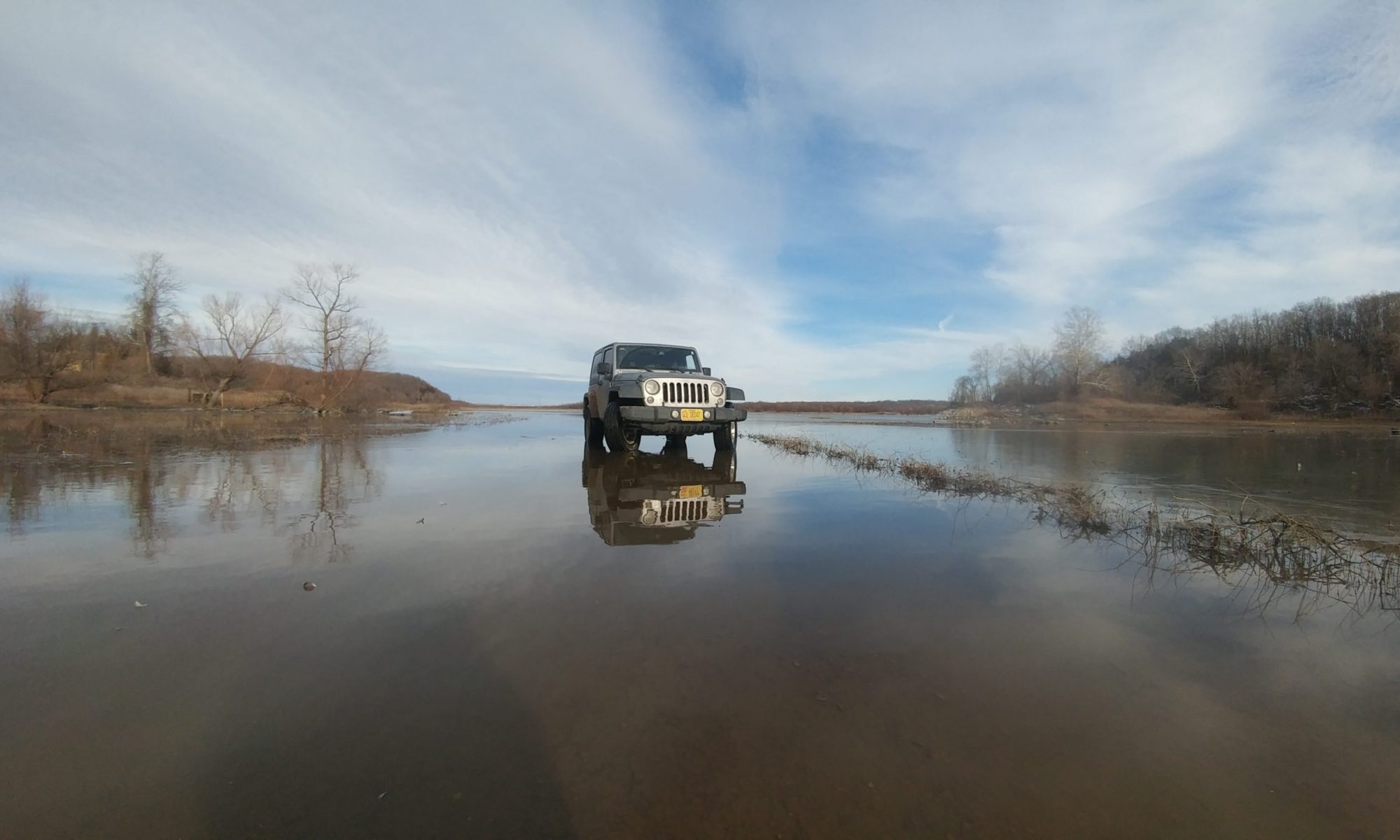
Looking at "29", my Jeep, from a Lenore Lake Cave
Technically these “caves” aren’t large enough to be considered a true cave. They never transition past a twilight zone, but they do hold some historical significance. About 5000 years ago the natives used these “caves” as shelters. The native people resided here during the spring and summer to collect plants and herbs that were used in religious ceremonies.
Don't wear flip flops when hiking up piles of loose basalt breakdown! June 22, 2011. Lenore Lake Caves
I hiked up the cliffs (in flip flops…I’m a bit of a rebel like that….) and visited the inside of the shelters. They would have been fairly comfortable, keeping everyone dry while still allowing for a great view of the canyon in front of them. Looking down to the parking area my Jeep looked dwarfed. The trail up to the shelters was dotted with several different flowering plants.
A Lenore Lake Caves flower. June 22, 2011
So far my visit to Washington had not met a single preconceived notion. I had been in the typical mountain terrain, I had taken in the views of waterfalls both ancient and current, and watched as this terrain turned from a high desert plain, sparsely vegetated, to a fertile land of farm land enriched by the Columbia river. When I arrived in Wenatchee, WA I finally saw the first thing that truely told me I was in Washington State: Cherry orchards.
As I learned back in the winter of 2009-2010, states are only bounded politically, not geologically or by climate. Washington State has a little bit of everything as I have learned today. Soon I would be in Seattle, experiencing the mighty Pacific Ocean. When I visited Northern Arizona in January 2010 I saw that Arizona was more than desert- it had snowy, vegetated mountain terrain. Today I visited Washington and discovered it wasn’t all cool and green- but it also had desert terrain. Arizona and Washington have more in common than I thought!
-Nicole
My drive across South Dakota was going to be a long one. I had not particular plans for today other than find a campsite that was within cell range so that my two friends that were to meet me there early tomorrow would be able to reach me. (I ended up staying in a hotel because my lovely cell phone company didn’t have service at any of the camps) I was heading west on I-90 and before I even hit the South Dakota state line I saw them: The Wall Drug bill boards.
Anyone who has driven through South Dakota is familiar with the barrage of billboards listing what Wall Drug has to offer. If you have driven through South Dakota and haven’t seen them, I strongly advise you to contact both your eyecare professional and your psychiatrist about some sort of disorder. They are literally everywhere, probably at least one every half mile. There is even one billboard that tells you about a Wall Drug billboard located in Africa….Really?
It’s actually quite a good advertising scheme. They adverstise so many different items that you start thinking it might be a good place to get your supplies. I mean, they have almost everything according to the bill boards that one by one list off the products Wall Drug has in store. It worked for me…I stopped by to get some dinner supplies only to find they didn’t really have groceries. I actually managed to find my way out of the labyrinth that is Wall Drug without spending a penny.
The prarie of South Dakota along I-90. June 14, 2011
Between bill boards you have a beautiful inspiring landscape. As far as the eye can see is nothing but big, open prarie with rolling hills that slowly transition into the bad lands, the black hills and the mountains. It is a gorgeous view and one of those constant reminders how much I love being in the West. The East is great to visit, and they have a lot to offer both culturally and naturally, but the only place you can find this much land untouched is in the West.
South Dakota along I-90.
The West was the last frontier of the United States, and because of this large portions of land were able to be stowed away without settlement. The first National Park and the first National Monument (both I will visit in the next few days) were both in the west. The National and State parks of this area are world-renowned for unique beauty and inspirational vistas that can be seen nowhere else. The landscapes are as gorgeous as they are varied, the west claiming tall, young mountains that are still growing, and older ranges that have begun to erode. A beautiful coastline that ranges from rocky points to sandy sun-bathed beaches lines the Pacific coast. The praries can be vast and flat as can be, and turn into rolling hills and rising plateaus. There are the lush rainforests in the West so filled to the brim with plants and animals it appears as an alien planet, as well as dry deserts home to very few animals or plants.
The mountains here are tall enough in places to have snow and ice year round, and even hosts some of the remaining glaciers of the continental U.S.
The West has always been more of who I am. It is the place where I can take a deep breath and feel….free. For the next month and a half…I was home.
-Nicole
A dragonfly on the prarie in South Dakota. June 14, 2011A storm rolling in at my hotel in Custer, SD. June 14, 2011
Travel is a complex activity that can originate from many different inspirations. Some of us travel to get away, others travel to learn, some travel to experience. No matter what the reason of travel, we all chose to go somewhere specific for one reason or another. Some of the places we visit because we have seen advertisements for them, read about them in books or online articles (such as this website, geojeep.com), or what we have heard from family and friends. My trip to Kennebunkport, Maine was one of the latter, and I dedicate this particular spot to my late paternal grandparents.
Me, sitting on the shore of Kennebunkport, Maine. May 24, 2011The ocean spray as the waves hit the cliffs of Kennebunkport, ME. May 24, 2011
They loved to travel, and went on as many trips to many places within the U.S. They passed away within 4 months of each other a little over a year ago, but I still remember clearly what how they described Kennebunkport. They had told me several times that someday, if I had the chance, I should visit the area. Today, I followed their advice and did just that.
Kennebunkport, ME coast. May 24, 2011
Kennebunkport Maine is along the Atlantic coast, almost as far south as you can get for the state. The coast mostly consists of rocky cliffs, constantly bombarded by the waves of the ocean, water spraying up high into the air when if find no other place to go. There are a few sandy beaches, but I would have to say this coast is not about basking in the sun and swiming in the sea: It’s about absorbing your surroundings, and drinking ni what a coastal environment has to offer for your health. I chose to play most of the day on ear, having booked a hotel less than 10 miles away at a Comfort Inn. I looked at the map and found the road closest to the ocean and simply headed in that direction.
Standing on the seaside cliffs of Kennebunkport, ME. May 24, 2011
I was pleasantly suprised by a beautiful coast, lined by granite outcrops that cut sharply down to the cold sea. Little did I know at that moment, but almost all of the area was just as scenic. As I followed the roads into the afternoon I couldn’t find a single spot that wasn’t as picturesque as the last.
I chose to eat dinner at a restaurant with a view of the ocean. Pier 77 was located on the coast, with a view of Cape Porpoise harbor where lobster boats come in during the season. It was here that I ordred lobster for the first time, and I have to say it was delicious.
Pier 77 restuarant, near Kennebunkport, Maine. May 24, 2011The view from my table at Pierr 77 in Maine. May 24, 2011Lobster in Maine. at Pier 77 near Kennebunkport. May 24, 2011
The chef had everything perfectly prepared, the greens with the perfect seasoning and everything was always artfully placed on the plate. My server was by far superior to most I have ever had the pleasure of dining with, especially considering he knew very well how to handle a single patron. Many try to overcompensate attention to a diner who is eating alone, but he had just the right mix of talk and space. I orderd a desert, the creme brulee, of which they serve garnished with an orchid blossom.
The Creme Brulee @ Pier 77 near Kennebunkport, ME. May 24, 2011If you haven't tried creme brulee, I encourage you to do so. Make sure you have a good chef. Pier 77, May 24, 2011Beign the orchid lover I am, I felt the need to reassemble my garnish. May 24, 2011 @ Pier 77 in Kennebunkport, ME
I finished dinner just in time for sunset, and as I rushed out the door to make sure I caught the sunset on my camera, to be viewed eternally, I noticed something to the east: A rainbow. This marks the third I have seen in this trip, and for something that is touted as so rare I am very thankful for this symbol of success. Everytime I see one I feel reassured that everything will be ok. I have been through many storms, but I will always find a rainbow afterwards.
The rainbow of Maine, May 24, 2011The partial rainbow outside Pier 77 in Kennebunkport, ME. May 24, 2011Sunset at Pier 77 in Maine. May 24, 2011
Tomorrow I will head from Maine to upstate New York to visit a relative of mine in the country. I can’t gurantee any rainbows, but I can gurantee this: Life is full of adventure, and the those who are truely successful in life are those who are active in the constant motion. We can’t control everything, but we can control our reactions to what life throws at us. Success is measured in our own eyes, and by no one else. Tomorrow is simply a promise to myself that I will succeed another day. You should do the same. I’ll see you there…
-Nicole
One of the many nice amenties you get for paying more for a hotel: An indoor pool at the Comfort Inn of Biddeford, ME (near Kennebunkport)The anchor dedicated to George Bush along the coast in Kennebunkport, ME. May 24, 2011The lobster ship dock near Pier 77 near Kennebunkport, ME. May 24, 2011A picture I title "Finne". May 24, 2011 in Maine.
As I have stated before in my Day 2 Water World, water is incredibly important to the success of a community. Not only is it a necessity of life, but it is also a viable means of transportation. While the advent of motorized vehicles made travel over land easier, it is still more efficient when shipping large amounts of goods to use waterways. No man-made transportation system, even trains, can transport such a large amount of goods on one vessel. This is why so many of the larger cities in the world, especially those of industry, are built upon waterways that can support this sort of transportation. The city of Savannah was built upon the banks of the Savannah River for this very purpose and the river was used for trade, and still is today. The exchange of goods isn’t the only thing that rivers provide: it is also an exchange of cultures, and sometimes the very founding blocks of a city’s soul.
One of the ships at Savannah's port. May 16, 2011
Savannah was the starting place for the colony of Georgia, beginning in 1733. James Oglethorpe arrived on the British galley “Anne” in this year, in Charleston, SC with 144 colonists and supplies to set up a port on the southern banks of the Savannah River. The city was built upon his design, the streets in a grid pattern with plenty of space for public buildings.
The Savannah Cotton Exchange building. May 16, 2011The cobble walks of Savannah, shaded by large oaks with spanish moss. May 16, 2011
Cotton was Savannah’s main export, and during the time it boasted the badge of being the top cotton export of the Atlantic, and the 2nd of the entire world. Over 2 million bales of cotton were moved through the port of Savannah every year during cotton’s peak. The port was used heavily throughout the 18th cenury, and in the 19th century they decided to put all of those cobbles used as ballasts in ships to good use. The urban geology (click here for my definition of urban geology) of Savannah is thus varied, having stones from all over the world incorporated into the streets and retaining walls. They come from places like the American Northeastern coast, Maritime Canada, Portugal, Spain, France, Madeira and more. A mix of many different rock types from the igneous (Basalt, Granite) to the sedimentary (sandstone, chert, limestone and more).
An old anchor on Savannah's River street, a local muscian plays alongside the fountain.
Today Savannah is still a major port, shipping out large amounts of goods on a regular basis. The ships are HUGE, it almost seems unnatural to see them floating through the river. While exports are still important, tourism is the Savannah prosperity of today, with thousands of visitors flocking to explore the beautiful city every day.
These ships are HUGE. Each of those containers are what typically sits on a semi truck. Do you see the person in orange for scale? No? Look at the next picture for a closer look.There he is, my little scale man. This ship is HUGE! Makes you wonder how deep the Savannah River actually is.... May 16, 2011
Savannah has a wide selection of excellent restaurants, everything from seafood to Italian. I went to “Vic’s on the River” as recommended by the lady who checked me into my hotel. The food was fantastic, the service was great, and the view from the balcony was beautiful. A quick storm passed through while I ate and enjoyed a half-bottle of wine, and afterward the sun came back out and a rainbow appeared. A sign of good fortune to me.
Inside the restaurant "Vic's on the River" in the River district of Savannah. Some of the very large wine selection offered at Vic's in Savannah, GA. May 16, 2011
The meals run between 20 and 30, so a little more pricey than I usually dine at, but the portions are large and the chef’s creations are wonderful. When you are eating at a restaurant like this, don’t insult the chef: order as it is described in the menu and don’t season until you’ve tasted. It always irks me when I am in a nice restaurant and a customer wants to order it without this and with this…it’s an insult. At a restaurant like this the chefs work hard to create a recipe that tastes just right. Enjoy it as it is. I enjoyed a large fillet of local flounder, breaded in Georgia pecans, with a citrus butter glaze atop potatoes and sausage. It was…delicious!!!
My meal at Vic's: Pecan encrusted local flounder atop pototoes and sausage with a citrus butter sauce. Mmmmmm May 16, 2011The rainbow that came out over the Savannah River, viewed from Vic's on the River's balcony. May 16, 2011
There are plenty of unique shops to explore, and although shopping isn’t quite my thing I found a few inexpensive trinkets, like a decorated mask and some earrings. There was also a shop that had everything made from bee products (the honey and the wax). It was quite an interesting store, and they have a large variety of different honey to sample and purchase. Many honey farms restrict their bees to certain areas of flowers (I.E. citrus, the tupelo plant, clover, etc) and it gives the honey a distinct flavor, texture and color. For more information, visit their website www.savannahbee.com
The Savannah Bee Company. Savannah River District. Georgia. May 16, 2011.A small selection of the types of honey the Savannah Bee Company offers. May 16, 2011
While I prefer to camp for several reasons outlined previously, there are some places where it just makes more sense to stay in a hotel. Savannah is one of those places. I was able to enjoy a wonderful free breakfast in the morning, free internet, a hot tub, and a comfortable bed. I don’t always stay at hotels, but when I do I stay at Choice Hotels (Comfort Inn, Comfort Suites, etc). They have the best breakfasts, decent rates, and they even have a free points card to redeem free nights. It is usually best, if you choose to travel via hotel, to pick a chain you like and stick to it so you can earn free nights. It is the best value you can get while staying in a hotel and you know what to expect at each location.
Savannah is a great place to visit, but tomorrow it is time to head towards the University of Georgia to see what the area has to offer. I’m starting my journey towards the northeast, just when I became used to seeing spanish moss draping from large oaks and large swampy area. I will have to say goodbye to the deep south, but I will not be saying goodbye to the river ways. Each river city has its own distinct culture, based upon their own goods for trade. I can’t recall right now which river is next along my journey, but for now it’s time to head towards the Carolinas and enjoy my last day in Georgia. See you all soon-
Nicole
"A World Apart", The WWII Memorial in Savannah, GA. May 16, 2011Being from a smaller town, I walk into a building expecting it to be what the sign on the outside says. Apparently each floor has it's own shop. Savannah, GA. May 16, 2011The back alley of Savannah's river district, paved in ballast cobbles. May 16, 2011This is the back view of that ship I saw float through Savannah... can you believe how big this is??? May 16, 2011My new mask from Savannah, GA. I love it! May 16, 2011